On my return to Mud village of Spiti valley (from the Pin-Parvati trek), I was surprised to find Simon, a traveller from the UK (Birmingham), still staying at Mud. He was there for the past 10 days.
The next day, on 4th Aug, after an early breakfast, I caught the 7 AM bus (along with Simon) from Mud to Kaza.
After about a 2 – 2.5 hour journey we landed at Kaza to get a trekking permit for the Parang-La Pass trek.
Parang-La Trek Permit
I had been informed that we need a permit to be made for the Parang-la trek. So after dumping my rucksack in Simon’s room, both of us went to the SDM Kaza office.
I was told to procure the form I had to fill from the “Xerox” shop opposite the SDM office building. Once I got the form (and a few spare copies for the benefit of others) I realized that it asked for “Passport information”.
On asking the courteous and helpful lady (at the SDM office) who was issuing the permits, on whether a driving license would do she said a passport would be preferred.
Luckily I had a copy of the passport in my rucksack. So I went back to the hotel and got the copy of the passport and filled the form with relevant details.
Found A Trek Partner for Parang-La
BTW, one needs 2-3 passport sized photographs too, so have it handy. After that I was given a file with my permit and was told to go to the SDM office and get my permit signed. So, with due respect I went to the next building, & got the approval from the SDM. After returning the file to the lady – I came back victorious with permit in hand.
Mind you the permit is issued with a validity period of 2 weeks. After lunch and replenishing my ration and supplies I caught the 4:30 p.m bus from Kaza to Kibber.
Related: Kinnaur Bus Timetable (New Timings)
While staying at the Serkong homestay in Kibber that evening I got introduced to the cook, Ved. He was a lad from Kullu and a mountaineer himself (basic/advance/MoI from ABVIMAS Manali). He was also very keen on trekking. When I told him about my plan to trek Parang-La, he got interested.
However, Ved was on a month contract (had completed 25 days) with the owner of the homestay (Mr Dorjee). I told him that all he needed to get was his sleeping mat, sleeping bag and mug/plate and he could join me for the trip. The next morning (5th Aug) after consulting with Mr Dorjee he decided to accompany me on the trek. Mr Dorjee offered him a sleeping bag and a mat. Thus I found a companion for the Parang-la trek.
Kibber To Rug Lungpa Trek
We (Ved and I) started off on 5th Aug around 9:00 AM from Kibber. Reached the village of Dumla in about an hour and a half. It is a nice and quaint village with a spattering of green in stark contrast to the barren brown mountain ranges surrounding it. This is also the last village you will find on the trek.


En route to Dumla, one can see some massive gorges and one can see a trolley that is really high above the gorge. Even the sight of it looks scary – just imagine crossing on it. From Dumla it is a steady ascent and traverses across the hills to Thaltak, which we reached by 1:30 p.m. We were both famished and decided to have lunch. Suddenly my MSR stove started giving me problems – the fuel pump was stuck. It took me about an hour to figure that all it needed was to oil (Lubricate) the washer inside.
However, by 3 p.m it started raining and so we decided to pitch tents and have our lunch & coffee here. Meanwhile, we noticed that another group had its tent about 100m or so above us. As the rain subsided we walked up to their tents to have a chat. It was a Ladakhi group and surprisingly very unlike Ladakhis they were not very warm or welcoming (though still by no means rude).
We got so put off that we decided that let us pack up (around 4 pm) and walk a bit further – in hindsight a wise decision. From Thaltak there is a steep descent to the Rug Lungpa and then for the next few hours, one walks amidst deep gorges along the river. Reminded me of the stretch of my trek along the Tsarap river from Phugtal to Tantak last year (2011).


After a couple of hours of walking, the track ascends precipitously high along with the remains of some old glacial moraine. Looking at the terrain and the time we decided that it was highly unlikely that we would find water anywhere above so we filled about 3.5 liters of water in the river and started the tiring ascent, with the additional 3.5 kg weight.
After an hour and half of ascent, it was getting dark and the relentless ascent seemed to never-ending. Luckily for us there was a piece of flat land large enough to accomodate a tent. So we camped here. I must say that the view from the tent overlooking the gorge was awesome.
Rug Lungpa – Borolen – Parang-La-Tosang Gongma Traverse
On 6th Aug we resumed our tiring ascent. In about 2 hours, around 10:30 a.m, we reached a campground called Boroglen (5200 M). Here there was an army unit that was also trying to cross the pass.
After a quick stop for tea, courtesy of the army, we continued our ascent towards the pass. It took us about 2.5-3 hours (around 1.30 pm) to get to the Parang-la pass (~5600 M), marked by cairns and prayer flags.
There were spectacular views from the Parang-La pass. After trying to capture the beauty in the camera we were off by 2 p.m. On either side, we were flanked by snow-covered glaciers and walls of ice. We had judged — based on footmarks — that the path must be through the snow-covered central area.


We veered off to the right which was covered with glaciers as we thought we saw a track there. I, later on, saw a track to the left flank, and so we decided to traverse the glacier all the way to the left. Crossing this snow-covered glacier is a dangerous affair. We had to cross the glacier flowing in a fairly wide ice-walled gully.
Related: Navigating India’s Deadliest Trekking Routes In India
The gully was so wide that jumping across it seemed too risky. One slip and we would slip to our death (no kidding or exaggeration). Ved was slightly ahead of me and I noticed that he had jumped across at one point. Not wanting to take the risk (with a much heavier backpack) I scoured up the slope to check if there was anypoint I could cross without jumping.
Having failed to find such a spot I kept walking along the ice-walled gully till I found a point that was just about 1 feet wide. Weighing the risks I decided to jump across. It had to be a really long jump, just to account for the margin that the snow at the edge of the gully might give way.
That hurdle crossed, I descended further along the snow covered glacier. Meanwhile I had lost sight of Ved and knowing that he was jumping across these snow covered gullies that I was fearing the worst. With this fear in mind I still kept descending after about 15 -20 mins I saw him waving from down below, having crossed the glacier.
I heaved a sigh of relief. Later in the evening he too confessed that not having seen me for 20–30 mins he too was extremely worried and anxious –fearing the worst. It is difficult to capture the feelings one experiences at such times in words.
Nevertheless, a burden off my chest, I descended further. The last stretch of the glacier is covered in hard ice and before reaching the rock-strewn area I slithered down several feet on this hard ice.
Finally, one could spot the trail (with cairns) among the rock strewn banks of Parang (Pare Chu) river, which was formed by the confluence of the several ice-cold streams emanating from the glacier. On the banks of the river where it started flattening out we decided to pause & have some coffee/maggi to reinvigorate ourselves after the experience of the past 2-3 hours.
Around 5 p.m we decided to walk to Kharsa Goma, the next campsite. After an hour, near Kharsa Goma we met a solo trekker from New Zealand carrying a backpack bigger than mine (almost 1.5 – 2 times) and he had been trekking from Rumtse and had reached here on the 8th day – not bad at all.
He mentioned that “just round the corner” there was another group camping. So, instead of camping at Kharsa Goma we decided to walk “just round the corner” and that took us another hour and involved crossing the Pare Chu river. We reached the campsite of Tosang Gongma by 7 p.m where we camped beside this group of Italians and Ladakhis.
Related: Backpacking through Spiti valley
Tosang Gongma To Racho Lamo Campsite
The next day on 7th Aug we started along with this group at 8:30 a.m. There was a retired Ladakhi Colonel in this group, who was trekking along with his son. He was passing on the legacy and showing the beauty of the Ladakhi landscape to his son through this trek.
The Colonel kept me entertained with some very interesting stories and experiences till noon whilst I walked along with him. Today was going to be a long day and since we had eaten a light breakfast we were feeling tired.
Overall there had been slight undulations in the terrain today but there were no major ascents/descents. The trail continued to wind its way along the banks of the Pare Chu river. The lack of packed lunch (unlike the accompanying group) did take a toll on our body. However, we still managed to soldier on and reached the Racho Lamo campsite by 4:30-5 p.m. I would leave the photographs to convey the beauty of the mesmerizing landscape as opposed to the words.
Racho Lamo Campsite To Korzok Village
Leaving early morning the next day we marched ahead. After about 3 hours of walking at around 11:00 a.m we had to cross the Pare Chu river and crossover into the Ladakh area –first time leaving Himachal Pradesh and entering J&K.
The Pare Chu continues onto Tibet and then re-enters India, feeding into Tso Moriri. Crossing the Pare Chu river is not easy. For a couple of steps, we had to battle strong currents in thigh high water. The rest was pretty crossable. Once we got across the Pare Chu, we stopped to rest our icy cold feet and change our wet socks before marching on.
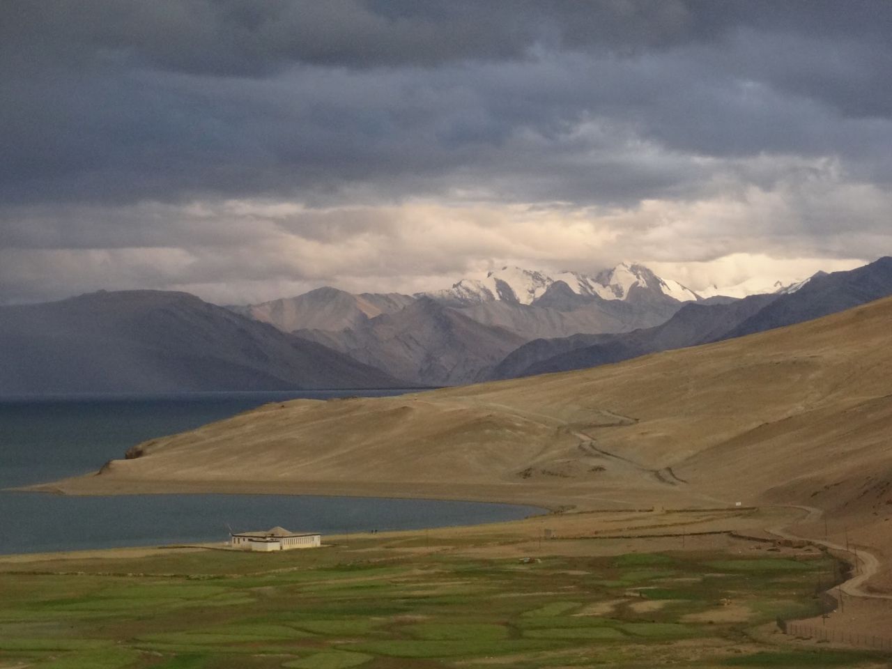
In about an hour we were at the campsite of Chumik Sale. This is where the other group was going to rest. Beyond Chumik Sale the terrain is flat as a pancake and strewn with rocks/pebbles and flanked by mountains on both sides. One can see the silver lining of Tso Moriri lake in the distance.
The Mirage of Tso Moriri Lake
This is almost like a mirage for it takes a good 3-3.5 hours of walking before you are actually close to Tso Moriri lake. Every 10 mins the silver lining of the lake seems to increase in width and you can see a bit more of the lake and one thinks the lake is very near — but alas that is not to be.
Tso Moriri Lake is really deceptive in terms of distance. Around 4:30 p.m, when we were still about 15-30 mins from the shores of the lake we stopped to rejuvenate ourselves with some coffee/maggi. This place is a lovely campsite called KiangDom.
As per the name one can see Kiangs or wild-asses in this area. These are a rare species of animals endemic to this area. After our coffee we marched on alongside the banks of the Tso Moriri, for an hour and a half, spellbound and captivated by its beauty till we reached Sanchanlung, where we camped. Tso Moriri is the most beautiful lake I have seen thus far. I would say it is even more beautiful than Pangong-Tso (or even Gokyo).
On 9th Aug we continued our walk along the Tso Moriri for another 3 hours till we reached the village of Korzok around 1 p.m.
Overall we managed the journey from Kibber to Korzok in 4.5 days (and could have possibly done it in 4 days). But for those reading this blog and planning please note that the normal itinerary, which most trekking companies would give, would be for 7 days. Even when you are planning please plan for 7 days for this trek.
Also it is much easier to do this trek from Korzok to Kibber as there are no major ascents, except just before the pass. Even this ascent to the pass is much lesser from Korzok side as opposed to from Kibber side.
Return Journey from Korzok to Bangalore
Unless you have pre-booked a cab from Leh, finding a vehicle/cab (to take you to Leh) at Korzok is very difficult and if you find one be prepared to shell a thousand (or few thousands).
The buses from Leh to Korzok come every 10 days (10th / 20th / 30th of the month) and reach Korzok in the evening. The same bus leaves the following morning to Leh (on 11, 21st, 31st of the month). Due to some confusion (miscommunication) we missed hitching a ride in the truck leaving from Korzok on the 10th morning. We deliberated on whether we should continue our trek to Tso kar / Rumtse but then thought we would be better off just walking the road.
We started walking at 10:00 a.m on the road. After about 30-45 mins of walking a dumper truck carrying grills of iron (the ones used to prevent landslides on the road) gave us a lift. We sat on the iron grills bracing ourselves for a long bumpy ride. The truck dropped us off at the end of Tso Moriri lake as he was headed to Chumar –the last village on the other side of the Tso Moriri lake bordering Tibet.
Though battered, we resumed our walk. We would have walked about 10 mins when we saw a few dumper trucks. We tried to thumb a ride but a few passed us before 1 noble soul stopped and let us hop in. We requested him to drop us to Sumdo but since he did not know where Sumdo village was he took us all the way to Mahe bridge. Now if we wanted to get to Tso Kar by road we had to get back to Sumdo, which was 12 kms away. We tried hitching a ride in a truck in the opposite direction but the trucks went only a km or 2. So, we hitched a ride and came back to Mahe bridge and decided to go to Upshi (en route to Leh). The TCP officer helped us in getting a ride on the back of a government pick-up vehicle all the way to Upshi, via the captivating Chumthang region. One of the most enjoyable and scenic mountain rides (in a natural AC environment on the rear of a pick-up truck) I have ever been on.
The next morning (4:00 a.m) we hitched a ride on 2 trucks going back towards Manali. This was faster & cheaper than the bus and far more comfortable. It was faster because the truck drivers don’t stop at Keylong for an overnight halt like the bus drivers do. We crossed Rohtang that night after 8 p.m. There was a traffic jam as “a Nano car” got stuck in the mud/slush on the Rohtang pass, the GREF vehicles (Earthmovers) came in the opposite direction and inched its way through the mud/slush, and a “drunk/obstinate” truck driver came and stopped head-on in front off the truck and refused to budge/back-up for over half an hour in the middle of the night (and we could not back out as there were 4 trucks behind us).
Overcoming all these obstacles we reached Manali around 1 pm that night and as it was raining we decided to sleep in the truck, instead of hunting for the hotel. The next morning after bathing in a hot spring and I had breakfast, we resumed our truck journey to be dropped at Bhuntar. A bus journey from Bhuntar to Mandi was followed by a bus journey to Chandigarh. We were delayed an hour on the bus journey to Chandigarh as a truck had toppled over and blocked the road after Bilaspur.
On the 12th evening, I boarded the HRTC bus to Delhi from Chandigarh, but about an hour into the journey both the rear tires on the left were flat. I then flagged down a truck (yet again) and was on my way to Delhi. Around midnight the truck driver decided to stop, to have dinner (which I shared with him on his truck), and decided to go off to sleep leaving me stranded in the middle of nowhere. Anyway, I decided to walk on the highway (with my heavy rucksack) after half an hour flagged down another HRTC bus, which dropped me off at Delhi, thankfully with any incidents at 3:00 a.m well in time to catch the 6:30 a.m Sampark Kranti express to Bangalore.


Sathyanarayan was a Bangaluru based solo trekker acclaimed for his recces and exploratory treks in north-western Nepal, Sikkim, Garhwal, Kinnaur, Spiti valley, Zanskar. In July 2018, on an exploratory trek from Kafnu to Ropa valley via Surcho-Listigarang-Yulla Kanda-Kashang Pass, Sathyanarayan disappeared somewhere near Surcho in Bhaba valley of Kinnaur. Sathya orginally planned for Pin Valley to Bhaba Nagar trek via Rupi and Sorang valley but changed his mind at the last minute. Before taking a sabbatical from working at Texas Instruments, Sathya did Advance Mountaineering Course (AMC) from Nehru Institute of Mountaineering, Uttarkashi. Sathya was pioneering in exploring the remotest regions of the Himalayas in the alpine trekking style using geo-referenced maps—a technique of assigning the coordinate system to the raster data obtained from a satellite or topographic image of a region.
Leave a Reply