

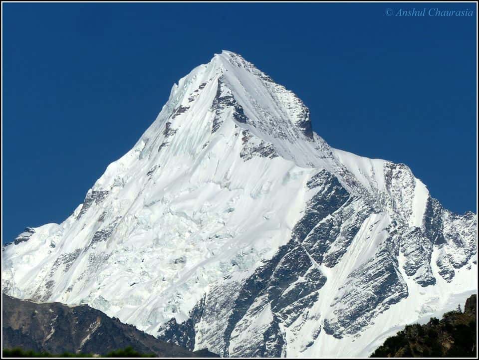
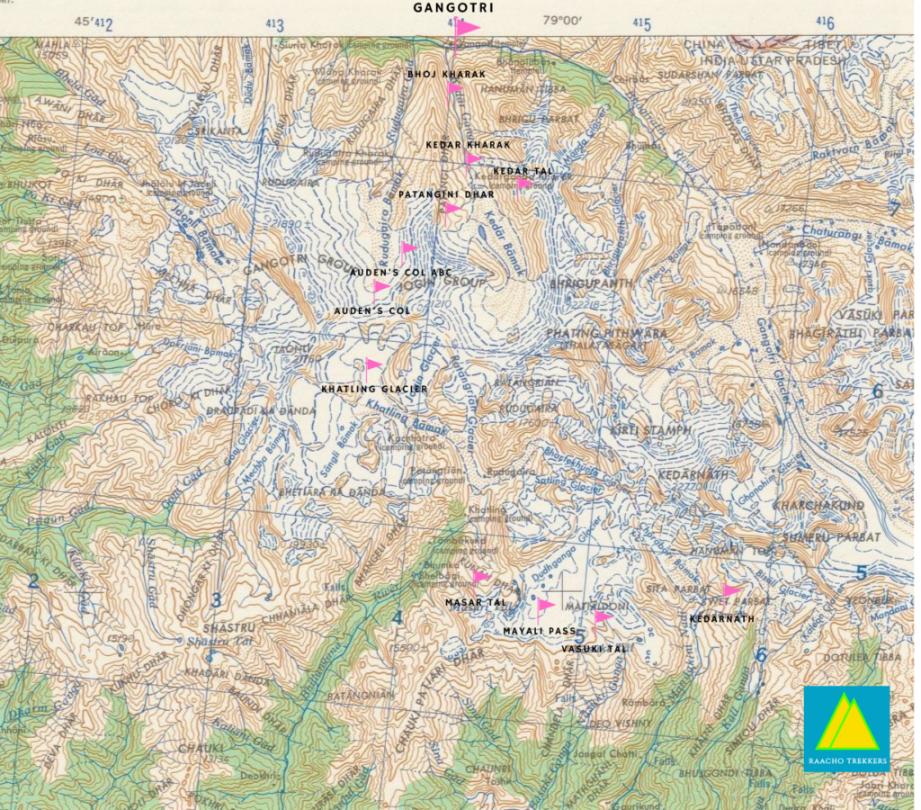
Auden’s Col is a pass in the Gangotri Group of mountains that connects Jogin I (6465m) and Gangotri III (6580m) and is reportedly situated at an altitude of around 5400m. It also binds two glaciers on the opposite sides. One is Khatling glacier and the other one looks like the glacier belonging to Jogin I.
Auden’s Col Trek Expedition: A photoblog
Auden’s Col is approachable from Gangotri and one can trek up to Kedarnath following Auden’s Col and Khatling glacier. The pass is named after John Bicknell Auden of the Geological Survey of India, who first discovered it in 1935 and crossed it in 1939. Mr. Harish Kapadia and Mr. Romesh Bhattacharjee from the Himalayan Club repeated Auden’s explorations in the late eighties.
Normally pass and the Khatling glacier is heavily infested with crevasses. However, we crossed the pass in early June and encountered few crevasses due to heavy snow cover. To read more about the expedition, please read this blog written by Neelima Vallangi on National Geographic Traveler. Sridevi Nair has also written a brief account of Auden’s col trek expedition 2018

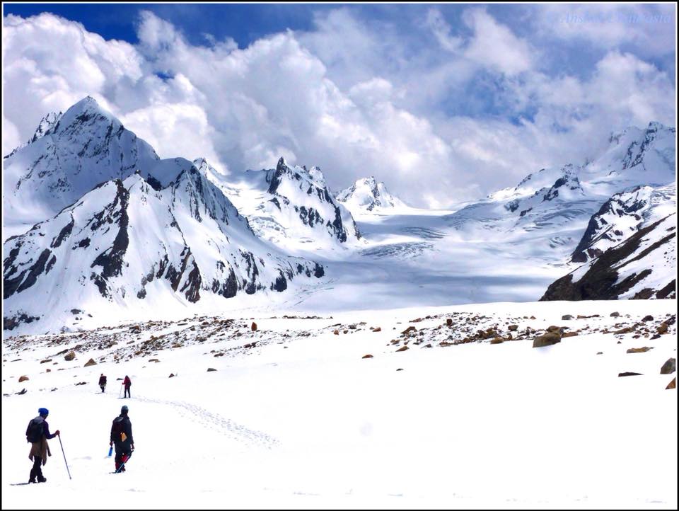
In between the Gangotri III and Jogin I, lies this amazingly beautiful pass which hides the crevasse-ridden Khatling glacier on its other side that one requires to cross while getting down. We crossed this as a part of tri-pass-route (Patangani Dhar-Auden’s Col-Mayali Pass).
Expedition’s highlights
- Auden: John Bicknell Auden, brother of the famous poet Auden, was a Geographical Survey officer. He discovered the Col in 1935 and finally crossed it in 1939.
- Col: the lowest point of a ridge or saddle between two peaks, typically providing a pass from one side of a mountain range to another.
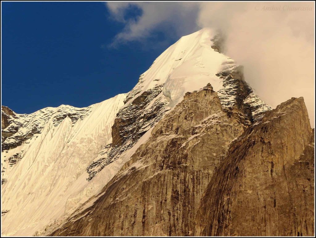
- Auden’s Col is one of the toughest and most challenging treks in the western Himalayas and definitely the most treacherous pass in the Garhwal Himalayas.
- It’s not a popular trek due to its level of difficulty.
- The Col is at a height of 5490 m – 18,000 feet. (That’s high).
- The terrain is strenuous and the trail passes through moraines, narrow cliffs, Boulders, and difficult ridges.
- The pass links two glaciers on the opposite sides, viz Khatling glacier and Jogin I glacier. The pass and the Khatling glacier are heavily infested with crevasses.
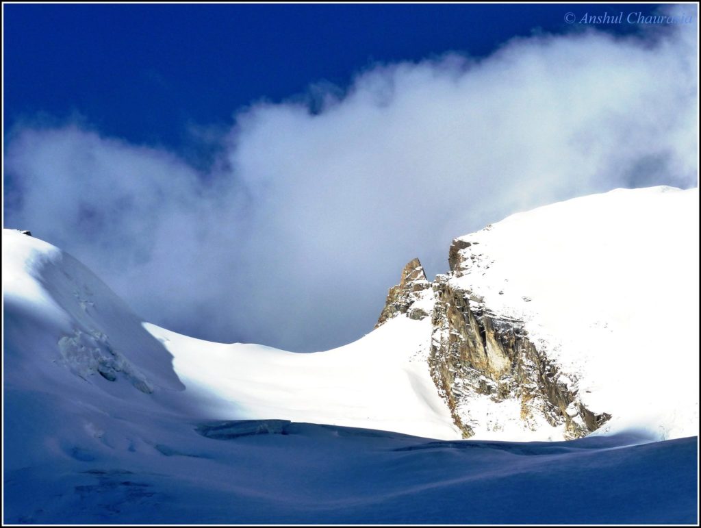
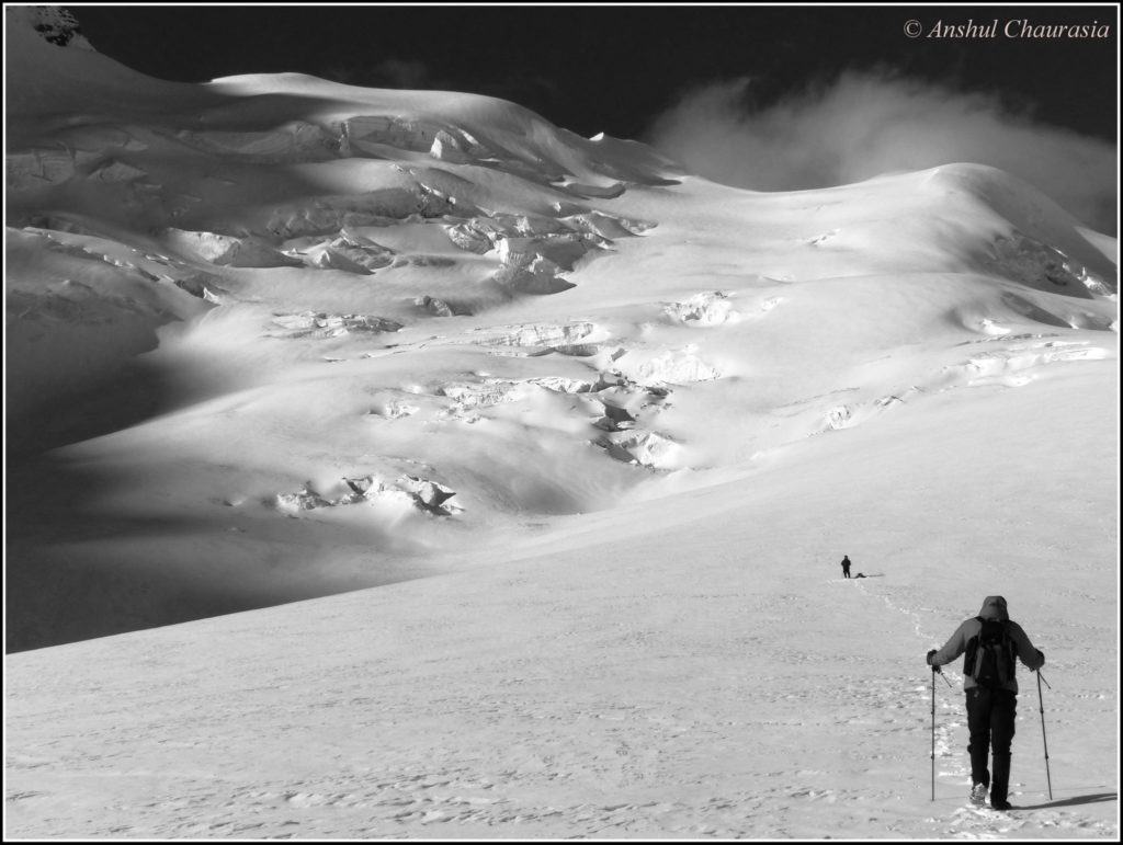
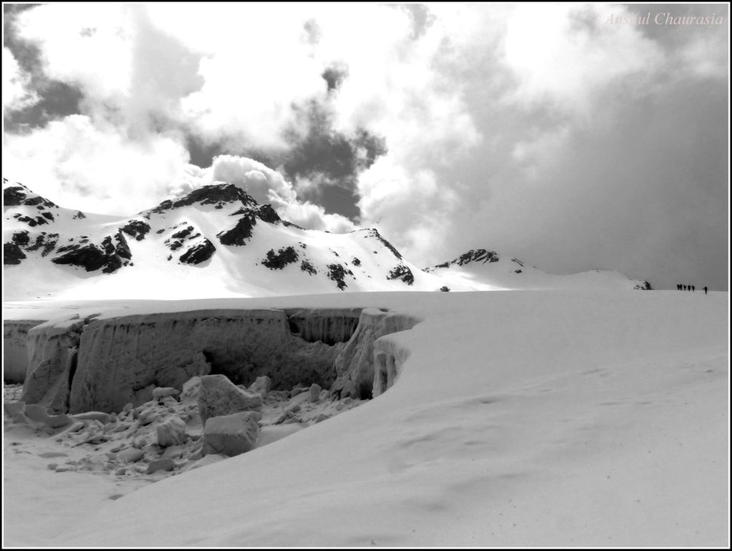
Gangotri to Auden’s col via Patangini Dhar

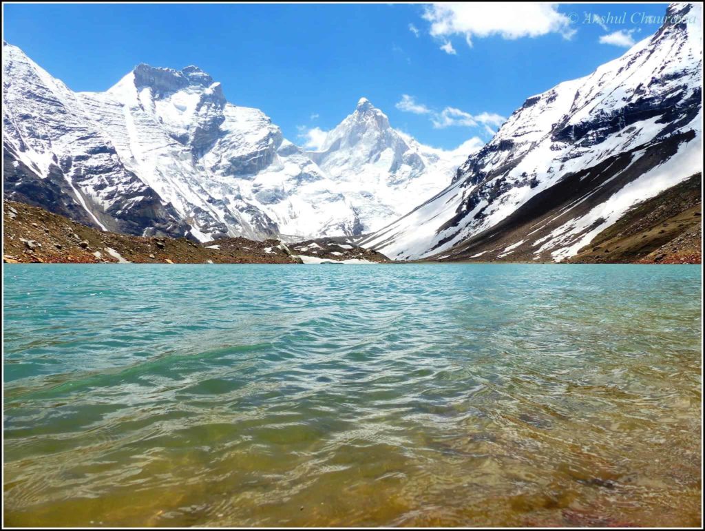
Kedartal lake
It is a snow-fed lake surrounded by Thalay Sagar (6,904m), Meru (6,672m), Bhrigupanth (6,772m) and other Gangotri group of peaks, and is the source of Kedar Ganga, which in Hindu mythology is considered to be Shiva’s contribution to Bhagirathi. Kedartal is 17 km from Gangotri. The route involves a steep rocky climb along the narrow Kedar Ganga gorge for 8 Km to Bhojkharak. From there it is 4km to the next available flat area for camping at Kedarkharak, and a further 5 km to Kedartal. The route passes through scenic Himalayan birch forests but is made hazardous in places by falling rocks, high altitude, and segments of steep ascent. Kedar Ganga originates from Kedartal and meets the Ganges in Gangotri.
![Mandakini peak [ Gangotri National Park ]](https://cdn.raachotrekkers.com/wp-content/uploads/2018/06/19144175_10158881063035593_8530491387949600153_o.jpg)
![Thalay Sagar peak (6904m) [ Gangotri National Park ]](https://cdn.raachotrekkers.com/wp-content/uploads/2018/06/19095409_10158880991580593_5025571360440675933_o.jpg)
![Thalay Sagar peak (6904m) [ Gangotri National Park ]](../wp-content/uploads/2018/06/19095409_10158880991580593_5025571360440675933_o.jpg)
![Bhrigupanth and Thalay Sagar [ Gangotri National Park ]](https://cdn.raachotrekkers.com/wp-content/uploads/2018/06/19095473_10158881056595593_3068284195308430507_o.jpg)
![Kedartal lake [Thalaysagar peak visible in the background] - Auden's col trek](https://cdn.raachotrekkers.com/wp-content/uploads/2018/06/19143762_10158881013350593_2944153246053842738_o.jpg)
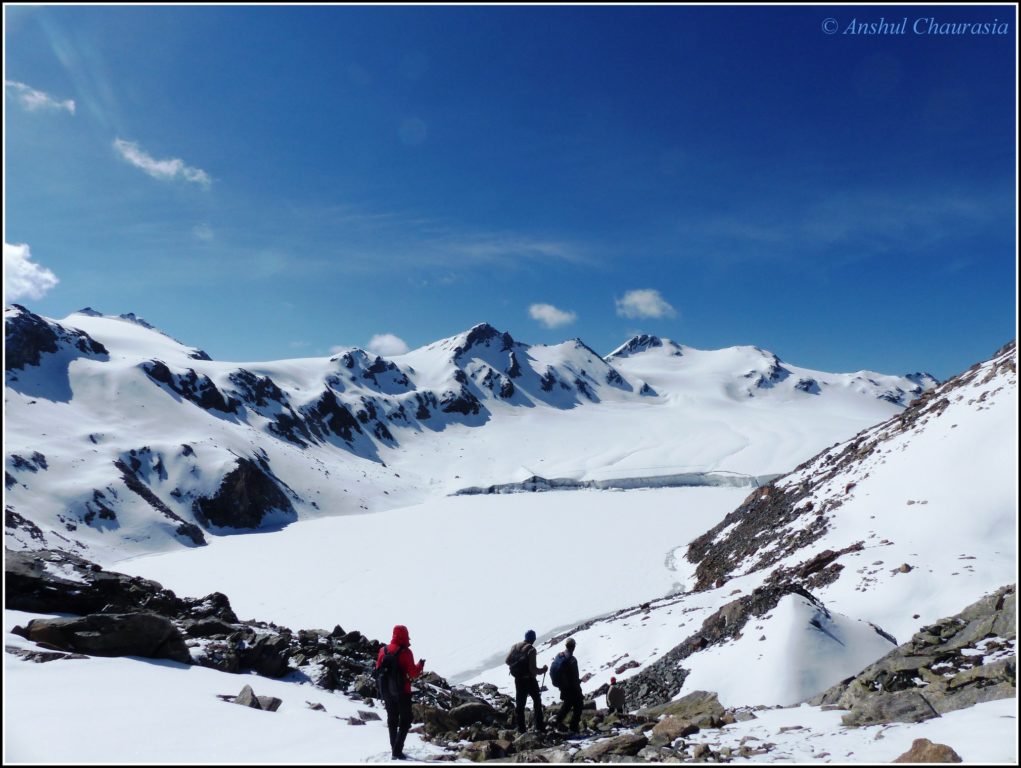
Auden’s col to Kedarnath via Khatling Glacier & Mayali pass
After crossing Auden’s col, there are two exit options. The first one is to exit through Masar Tal – Mayali pass – Vasuki Tal to Kedarnath. The other is to exit through the trek route which is from Tambakund, Kharsoli, Gangi to Village Guttu. Village Guttu is a day’s journey from Haridwar or Rishikesh.
![Climbing Auden's col [The three passes trek Auden's col - Mayali pass - Patangini Dhar]](https://cdn.raachotrekkers.com/wp-content/uploads/2018/06/19221861_10158894757470593_5599948967909241507_o.jpg)
![Huge icefalls near Khatling Glacier [Auden's col trek]](https://cdn.raachotrekkers.com/wp-content/uploads/2018/06/19400193_10158920664995593_274628646501295022_o.jpg)
![Sheer vastness of the Khatling Glacier [Auden's col trek]](https://cdn.raachotrekkers.com/wp-content/uploads/2018/06/19400492_10158920664330593_9025951396601337183_o.jpg)
![Masar top, Enroute Mayali pass [Auden's col trek]](https://cdn.raachotrekkers.com/wp-content/uploads/2018/06/19466619_10158943490310593_8591916301329040975_o.jpg)
Related: Auden’s Col (Rabbit is calling) 3-pass Trek Blog
Our guide told us that he had come here three times before. The first time when he came 10-12 years back the glacier used to start right away from the point where you see us standing (in this pic) till it joined the surrounding mountains.
But the glacier has now receded as much as the black line you can see somewhat in the middle. It has left a glacial pool (uncrossable as it breaks) which makes the crossing much difficult as one needs to skirt across the moraine field on the right hugging the slopes and then join the glacier after it receded point.
Related: Harsh Reality of Trekking in India: Cases of Avoidable Accidents
Maybe with the rate of global warming, this glacier might only be in photos over the next 10–12 years.
Auden’s Col Trek Itinerary:
- Day 0: Reached Gangotri (2940m), acclimatization day, visit the temple
- Day #1: Trekked to Bhoj Kharak (3415m)
- Day #2: Trekked to Kedar Kharak (4315m)
- Day #3: Trekked to Kedar Tal (4760m) and back to Kedar Kharak
- Day #4: Trekked to Patangini Dhar base campsite (4540m)
- Day #5: Crossed Patangini Dhar (5085m) and reached Dhabba Camp Site (4685m) in Rudugaira valley
- Day #6: Trekked to Rudugaira / Auden’s Col Advanced Base Camp (4975m)
- Day #7: Crossed Auden’s Col (5490m), trekked on Khatling and reached Khatling campsite (4970m)
- Day #8: Trekked rest of the Khatling, crossed waterfall area (4300m) and reached Khatling Base camp (3765m)
- Day #9: Crossed Bhilangna river (3480m), and reached Chowki campsite (3630m)
- Day #10: Trekked to Masar Tal (4550m)
- Day #11: Trekked to Masar Top (4695m), Crossed Mayali Pass (4990m) and camp (4335m) near Vasuki Tal
- Day 12: Trekked Vasuki Tal (4210m), trek to Vasuki Top (4480m), and descended to Kedarnath (3530m)

[starbox]


After completing engineering, Anshul worked in Bangalore and hiked umpteen passes of Eastern and the Western Ghats. He started his Himalayan journey with Stok Kangri trek. In 2014, he did the basic mountaineering course from Nehru Institute of Mountaineering, Uttarkashi. Besides trekking and mountaineering, Anshul loves backpacking and traveling to new places. During his MBA course in France, he backpacked across Europe and managed to visit 36 countries. Anshul did 3 passes trek (Auden’s 5490 m, Mayali and Patangini Dhar) in 2017 and Panpatia Col (5260 m) in 2019. Anshul and his wife Arpita write about their trekking and backpacking adventures on Backpacker Crows blog.
Leave a Reply Cancel reply